 Site Map |
|
 |
A chronological list of dates Section Two : Post 1900 |  |
| 1900 | Rose Terrace erected in Station Road. | ||||||||||||||||||||||||||||||||||||||||||||||||||||||||||||||||||||||||||||||||||||||||||||||||||||||||||||||||||||||||||||||||||||||||||||||||||||||||||||||||||||||||||||||||||||||||||||||||||||||||||||||||||||||||||||||||||||||||||||||||||||||||||||||||||||||||||||||||||||||||||||||||||||||||
| 1901 | Census listed 25 farms and gave the population as 1,281. | ||||||||||||||||||||||||||||||||||||||||||||||||||||||||||||||||||||||||||||||||||||||||||||||||||||||||||||||||||||||||||||||||||||||||||||||||||||||||||||||||||||||||||||||||||||||||||||||||||||||||||||||||||||||||||||||||||||||||||||||||||||||||||||||||||||||||||||||||||||||||||||||||||||||||
| 1902 | The Railway Station was moved to a new site just north of the level crossing. Within two years a large goods yard had also developed which dealt with mill traffic, coal and bricks. There were also private sidings for George Hargreaves and Co owners of the Huncoat Colliery. | ||||||||||||||||||||||||||||||||||||||||||||||||||||||||||||||||||||||||||||||||||||||||||||||||||||||||||||||||||||||||||||||||||||||||||||||||||||||||||||||||||||||||||||||||||||||||||||||||||||||||||||||||||||||||||||||||||||||||||||||||||||||||||||||||||||||||||||||||||||||||||||||||||||||||
| 1903 | Mitton Terrace erected in Burnley Lane. | ||||||||||||||||||||||||||||||||||||||||||||||||||||||||||||||||||||||||||||||||||||||||||||||||||||||||||||||||||||||||||||||||||||||||||||||||||||||||||||||||||||||||||||||||||||||||||||||||||||||||||||||||||||||||||||||||||||||||||||||||||||||||||||||||||||||||||||||||||||||||||||||||||||||||
| 1903 | Perseverance Mill referred to in contemporary writings as "Highbrake Mill". | ||||||||||||||||||||||||||||||||||||||||||||||||||||||||||||||||||||||||||||||||||||||||||||||||||||||||||||||||||||||||||||||||||||||||||||||||||||||||||||||||||||||||||||||||||||||||||||||||||||||||||||||||||||||||||||||||||||||||||||||||||||||||||||||||||||||||||||||||||||||||||||||||||||||||
| 1904 | A sewage and outfall works was established near Holker House below the brick viaduct. | ||||||||||||||||||||||||||||||||||||||||||||||||||||||||||||||||||||||||||||||||||||||||||||||||||||||||||||||||||||||||||||||||||||||||||||||||||||||||||||||||||||||||||||||||||||||||||||||||||||||||||||||||||||||||||||||||||||||||||||||||||||||||||||||||||||||||||||||||||||||||||||||||||||||||
| 1904 | Pleasant View terrace erected in Burnley Road. | ||||||||||||||||||||||||||||||||||||||||||||||||||||||||||||||||||||||||||||||||||||||||||||||||||||||||||||||||||||||||||||||||||||||||||||||||||||||||||||||||||||||||||||||||||||||||||||||||||||||||||||||||||||||||||||||||||||||||||||||||||||||||||||||||||||||||||||||||||||||||||||||||||||||||
| 1905 | Two local grocers Grime and Parkinson drowned in the canal possibly under the influence of intoxication. Parkinson’s house and shop near the Baptist chapel were presently demolished. | ||||||||||||||||||||||||||||||||||||||||||||||||||||||||||||||||||||||||||||||||||||||||||||||||||||||||||||||||||||||||||||||||||||||||||||||||||||||||||||||||||||||||||||||||||||||||||||||||||||||||||||||||||||||||||||||||||||||||||||||||||||||||||||||||||||||||||||||||||||||||||||||||||||||||
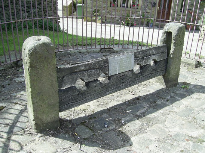
| 1906 | Pipers Row had been cleared to widen Highergate Road and the village stocks re-positioned on the site of the old cottage back gardens, and placed within iron railings. Pipers Row had got its name because a musical family had once lived there. (See 1844 and 1992). | ||||||||||||||||||||||||||||||||||||||||||||||||||||||||||||||||||||||||||||||||||||||||||||||||||||||||||||||||||||||||||||||||||||||||||||||||||||||||||||||||||||||||||||||||||||||||||||||||||||||||||||||||||||||||||||||||||||||||||||||||||||||||||||||||||||||||||||||||||||||||||||||||||||||||
| 1907 | A tram service commenced from Accrington to the cemetery gates at Hillock Vale on 26th October. | ||||||||||||||||||||||||||||||||||||||||||||||||||||||||||||||||||||||||||||||||||||||||||||||||||||||||||||||||||||||||||||||||||||||||||||||||||||||||||||||||||||||||||||||||||||||||||||||||||||||||||||||||||||||||||||||||||||||||||||||||||||||||||||||||||||||||||||||||||||||||||||||||||||||||
| 1908 | Huncoat Primary School opened on 4th April (Methodist day school therefore ceased on 1st April). | ||||||||||||||||||||||||||||||||||||||||||||||||||||||||||||||||||||||||||||||||||||||||||||||||||||||||||||||||||||||||||||||||||||||||||||||||||||||||||||||||||||||||||||||||||||||||||||||||||||||||||||||||||||||||||||||||||||||||||||||||||||||||||||||||||||||||||||||||||||||||||||||||||||||||
| 1908 | Anglican worship was again thriving so Huncoat branched away from St James’s at Church Kirk to become its own parish. The Foundation stone of St.Augustine’s Church being laid on 4th July by Mr H.H. Bolton of Highbrake House (see 1896 and 1909). | ||||||||||||||||||||||||||||||||||||||||||||||||||||||||||||||||||||||||||||||||||||||||||||||||||||||||||||||||||||||||||||||||||||||||||||||||||||||||||||||||||||||||||||||||||||||||||||||||||||||||||||||||||||||||||||||||||||||||||||||||||||||||||||||||||||||||||||||||||||||||||||||||||||||||
| 1909 | On the on 29th September the Monument on top of the Coppice was ceremoniously unveiled to mark the gift of land to the town of Accrington by William Peel, hence the name of Peel Park. His family originated from Peel Fold, Oswaldtwistle and were notable for Sir Robert Peel the Prime Minster and founder of the Police force. Some of the land was purchased at a favourable price and the Peel family donated the remainder. The work of laying out the park was implemented to coincide with periods of depression and so alleviate local unemployment. Mr William Peel officially opened the park during a ceremony which included a procession of 5,000 children from local schools, three bands and civic dignitaries walking from Avenue Parade to the top of the Coppice. The schools represented on the procession; Cambridge Street, St Anne's, St Mary Magdalene's, Hargreaves Street, St Andrew's, St Mary's Woodnook, Spring Hill, St John's, Hyndburn Park, Benjamin Hargreaves, St Peter's, St Oswald's, St John's Baxenden, Green Haworth and St James'. | ||||||||||||||||||||||||||||||||||||||||||||||||||||||||||||||||||||||||||||||||||||||||||||||||||||||||||||||||||||||||||||||||||||||||||||||||||||||||||||||||||||||||||||||||||||||||||||||||||||||||||||||||||||||||||||||||||||||||||||||||||||||||||||||||||||||||||||||||||||||||||||||||||||||||
| 1909 | St.Augustine's Church consecrated on 30th November by the Lord Bishop of Manchester. Although there were many coal mining workings under this area a pillar of coal was left undisturbed under the church to avoid subsidence. | ||||||||||||||||||||||||||||||||||||||||||||||||||||||||||||||||||||||||||||||||||||||||||||||||||||||||||||||||||||||||||||||||||||||||||||||||||||||||||||||||||||||||||||||||||||||||||||||||||||||||||||||||||||||||||||||||||||||||||||||||||||||||||||||||||||||||||||||||||||||||||||||||||||||||
| 1909 |
The Ordnance Survey map of this date showed - * The Corporation tram lines running up Burnley Road as far as Hillock Vale Mill * The network of mineral railways associated with mining and brick making * A Huncoat Fireclay works beside the railway line just south west of the level crossing * Altham Brick and Tile works by the canal had become Burnley Brick and Lime works * Huncoat Sewage works had been completed * The village stocks were marked for the first time (see 1906) * Rockdale in Burnley Road still bore that name (see 1931) * Waterside Cottage had been built by the canal * Targets at the Rake Head firing range had become disused | ||||||||||||||||||||||||||||||||||||||||||||||||||||||||||||||||||||||||||||||||||||||||||||||||||||||||||||||||||||||||||||||||||||||||||||||||||||||||||||||||||||||||||||||||||||||||||||||||||||||||||||||||||||||||||||||||||||||||||||||||||||||||||||||||||||||||||||||||||||||||||||||||||||||||
| 1910 | Over a hundred coke ovens had been erected at the colliery. | ||||||||||||||||||||||||||||||||||||||||||||||||||||||||||||||||||||||||||||||||||||||||||||||||||||||||||||||||||||||||||||||||||||||||||||||||||||||||||||||||||||||||||||||||||||||||||||||||||||||||||||||||||||||||||||||||||||||||||||||||||||||||||||||||||||||||||||||||||||||||||||||||||||||||
| 1910 | Willy Watkinson’s popular sweet shop occupied the northern end of Stone Hey cottages. | ||||||||||||||||||||||||||||||||||||||||||||||||||||||||||||||||||||||||||||||||||||||||||||||||||||||||||||||||||||||||||||||||||||||||||||||||||||||||||||||||||||||||||||||||||||||||||||||||||||||||||||||||||||||||||||||||||||||||||||||||||||||||||||||||||||||||||||||||||||||||||||||||||||||||
| 1910 | The Baptist’s celebrated their 100th Anniversary on 16th May by laying six foundation stones for a new building on the old Methodist ground fronting onto Burnley Lane. | ||||||||||||||||||||||||||||||||||||||||||||||||||||||||||||||||||||||||||||||||||||||||||||||||||||||||||||||||||||||||||||||||||||||||||||||||||||||||||||||||||||||||||||||||||||||||||||||||||||||||||||||||||||||||||||||||||||||||||||||||||||||||||||||||||||||||||||||||||||||||||||||||||||||||
| 1911 | Population reached nearly 1500. Many small shops lined both sides of Station Road. | ||||||||||||||||||||||||||||||||||||||||||||||||||||||||||||||||||||||||||||||||||||||||||||||||||||||||||||||||||||||||||||||||||||||||||||||||||||||||||||||||||||||||||||||||||||||||||||||||||||||||||||||||||||||||||||||||||||||||||||||||||||||||||||||||||||||||||||||||||||||||||||||||||||||||
| 1911 | The impressive new Baptist Church was opened on Good Friday. | ||||||||||||||||||||||||||||||||||||||||||||||||||||||||||||||||||||||||||||||||||||||||||||||||||||||||||||||||||||||||||||||||||||||||||||||||||||||||||||||||||||||||||||||||||||||||||||||||||||||||||||||||||||||||||||||||||||||||||||||||||||||||||||||||||||||||||||||||||||||||||||||||||||||||
| 1911 | The Lady Macalpine shelter was erected on top of the Coppice (see 2008). | ||||||||||||||||||||||||||||||||||||||||||||||||||||||||||||||||||||||||||||||||||||||||||||||||||||||||||||||||||||||||||||||||||||||||||||||||||||||||||||||||||||||||||||||||||||||||||||||||||||||||||||||||||||||||||||||||||||||||||||||||||||||||||||||||||||||||||||||||||||||||||||||||||||||||
| 1911 | The Huncoat Bank recreation ground of just over 5˝ acres was purchased by the Council from the Earl of Abingdon and Trustees on 14th July. (See 1878 and 1930). | ||||||||||||||||||||||||||||||||||||||||||||||||||||||||||||||||||||||||||||||||||||||||||||||||||||||||||||||||||||||||||||||||||||||||||||||||||||||||||||||||||||||||||||||||||||||||||||||||||||||||||||||||||||||||||||||||||||||||||||||||||||||||||||||||||||||||||||||||||||||||||||||||||||||||
| 1912 | The railway station was substantially rebuilt with a booking office, general waiting room, ladies room, parcel office, porter’s room, lamp room and toilets all being provided. | ||||||||||||||||||||||||||||||||||||||||||||||||||||||||||||||||||||||||||||||||||||||||||||||||||||||||||||||||||||||||||||||||||||||||||||||||||||||||||||||||||||||||||||||||||||||||||||||||||||||||||||||||||||||||||||||||||||||||||||||||||||||||||||||||||||||||||||||||||||||||||||||||||||||||
| 1913 |
The Ordnance Survey map of this date showed - * A tramway to Rake Head Quarry between the rifle range and Kings Highway * Ing Field behind the Coppice was now called Green Field * Whinney Hill Brickworks on the SE slope of Whinney Hill close to Hard Farm * Accrington Cricket Ground no longer included "Football" in it's legend | ||||||||||||||||||||||||||||||||||||||||||||||||||||||||||||||||||||||||||||||||||||||||||||||||||||||||||||||||||||||||||||||||||||||||||||||||||||||||||||||||||||||||||||||||||||||||||||||||||||||||||||||||||||||||||||||||||||||||||||||||||||||||||||||||||||||||||||||||||||||||||||||||||||||||
| 1914 | Burnley Brick and Lime Works and Huncoat Fireclay Works both ceased operations during the First World War. | ||||||||||||||||||||||||||||||||||||||||||||||||||||||||||||||||||||||||||||||||||||||||||||||||||||||||||||||||||||||||||||||||||||||||||||||||||||||||||||||||||||||||||||||||||||||||||||||||||||||||||||||||||||||||||||||||||||||||||||||||||||||||||||||||||||||||||||||||||||||||||||||||||||||||
| 1918 | A purely “Accrington” parliamentary constituency was formed but the parishes of Huncoat and Hapton were included in the Clitheroe constituency (see 1950). | ||||||||||||||||||||||||||||||||||||||||||||||||||||||||||||||||||||||||||||||||||||||||||||||||||||||||||||||||||||||||||||||||||||||||||||||||||||||||||||||||||||||||||||||||||||||||||||||||||||||||||||||||||||||||||||||||||||||||||||||||||||||||||||||||||||||||||||||||||||||||||||||||||||||||
| 1919 |
“In response to a general desire on the part of the inhabitants, a Parish Meeting was convened on 21st May to consider the advisability of giving a “Welcome Home” to the men of Huncoat who served in H.M. Forces during the late war, and to further consider the best way of commemorating the heroic sacrifice of those who have given their lives for liberty and justice. A committee was appointed, consisting of members of the Parish Council, the Overseers, representatives of ex-servicemen, the various religious organisations of the village, the working men’s club and the Loyal Highbrake Lodge of the Independent Order of Odd Fellows. The “Welcome Home” was given and Peace celebrations were duly observed. In October and at the request of the Parish Council, the Committee was empowered to raise funds for the erection of a permanent war memorial. A subscription list was opened early in 1920, special collections were made in the churches and a house to house collection which resulted in the sum of Ł304 being raised. The Committee realised the necessity of obtaining professional help and William J Newton Esq Borough Engineer and Surveyor to the Corporation of Accrington was approached by a deputation and he most readily placed his services at the disposal of the Committee. Two designs were submitted in August 1921 one of which was selected and an estimate for the same approved." | ||||||||||||||||||||||||||||||||||||||||||||||||||||||||||||||||||||||||||||||||||||||||||||||||||||||||||||||||||||||||||||||||||||||||||||||||||||||||||||||||||||||||||||||||||||||||||||||||||||||||||||||||||||||||||||||||||||||||||||||||||||||||||||||||||||||||||||||||||||||||||||||||||||||||
| 1921 | Census revealed a decline in population to 1,380. | ||||||||||||||||||||||||||||||||||||||||||||||||||||||||||||||||||||||||||||||||||||||||||||||||||||||||||||||||||||||||||||||||||||||||||||||||||||||||||||||||||||||||||||||||||||||||||||||||||||||||||||||||||||||||||||||||||||||||||||||||||||||||||||||||||||||||||||||||||||||||||||||||||||||||
| 1921 | Three brothers, Harry, Jack and John died in the First World War along with 41 other men of Accrington collieries. Their father Henry and his remaining son Geoffrey unveiled a memorial window in St Augustine’s Church in 1921. A memorial tablet was moved to the church from Highbrake House in 1939. The Bolton Family were proprietors of Huncoat Colliery and lived at Highbrake House. Geoffrey Bolton went on to became Chairman of the NW Coal Board after nationalisation in 1948. (See also 1948). | ||||||||||||||||||||||||||||||||||||||||||||||||||||||||||||||||||||||||||||||||||||||||||||||||||||||||||||||||||||||||||||||||||||||||||||||||||||||||||||||||||||||||||||||||||||||||||||||||||||||||||||||||||||||||||||||||||||||||||||||||||||||||||||||||||||||||||||||||||||||||||||||||||||||||
| 1922 | On 29th April 1922 a crowd of dignitaries, officials, members of the memorial committee, relatives of the fallen, ex-servicemen, girl guides, boy scouts and members of the Ancient Order of Buffaloes assembled outside the primary school to make procession to the new memorial led by the 8th Battalion East Lancashire Regimental Band. The un-veiling Ceremony was performed by H.H. Bolton Esq. MBE JP. The souvenir “Book of Remembrance and Programme of Proceedings” said “All ye that pass by, remember with gratitude the Men who died for you!”
“The Memorial is in the form of a cross executed in Grey Longridge Stone. It is 16 feet 6 inches in height and 9 feet 6 inches wide at the base which is formed of three tiers of steps 2 feet 7 inches in height on which the pedestal is fixed. Here is inscribed the Dedication and the names of the fallen.”
The names of 25 men of the village who gave their lives in the First World War are recorded.
"To our glorious dead. This memorial was erected by public subscription, AD1922 in eternal remembrance of the men of Huncoat who gave their lives for King and Country in the Great War, 1914-1918. Greater love hath no man than this." “The shaft of the Cross rests on the pedestal and is 10 feet 6 inches in height. In order to prevent damage to the Memorial by children it has been surrounded with a stone kerb and wrought iron railing. The Memorial stands in a commanding position in the Public Recreation Grounds some 675 feet above ordnance datum. The total cost, including all charges, is about Ł320, which has been subscribed by the public. The work, which was let by tender, has been carried out by Messrs. Thos. Hodgkinson & Sons, Preston." | ||||||||||||||||||||||||||||||||||||||||||||||||||||||||||||||||||||||||||||||||||||||||||||||||||||||||||||||||||||||||||||||||||||||||||||||||||||||||||||||||||||||||||||||||||||||||||||||||||||||||||||||||||||||||||||||||||||||||||||||||||||||||||||||||||||||||||||||||||||||||||||||||||||||||
| 1926 | Hillock Vale cotton mill ceased production. | ||||||||||||||||||||||||||||||||||||||||||||||||||||||||||||||||||||||||||||||||||||||||||||||||||||||||||||||||||||||||||||||||||||||||||||||||||||||||||||||||||||||||||||||||||||||||||||||||||||||||||||||||||||||||||||||||||||||||||||||||||||||||||||||||||||||||||||||||||||||||||||||||||||||||
| 1928 | Huncoat ratepayers voted in favour of amalgamation with Accrington. | ||||||||||||||||||||||||||||||||||||||||||||||||||||||||||||||||||||||||||||||||||||||||||||||||||||||||||||||||||||||||||||||||||||||||||||||||||||||||||||||||||||||||||||||||||||||||||||||||||||||||||||||||||||||||||||||||||||||||||||||||||||||||||||||||||||||||||||||||||||||||||||||||||||||||
| 1928 | Highbrake Hall gutted by a fire. | ||||||||||||||||||||||||||||||||||||||||||||||||||||||||||||||||||||||||||||||||||||||||||||||||||||||||||||||||||||||||||||||||||||||||||||||||||||||||||||||||||||||||||||||||||||||||||||||||||||||||||||||||||||||||||||||||||||||||||||||||||||||||||||||||||||||||||||||||||||||||||||||||||||||||
| 1928 | The first bus service ran through the village in November. Tragically, a well known villager was crushed and killed at this event by the bus reversing at the railway station terminus. | ||||||||||||||||||||||||||||||||||||||||||||||||||||||||||||||||||||||||||||||||||||||||||||||||||||||||||||||||||||||||||||||||||||||||||||||||||||||||||||||||||||||||||||||||||||||||||||||||||||||||||||||||||||||||||||||||||||||||||||||||||||||||||||||||||||||||||||||||||||||||||||||||||||||||
| 1929 | Huncoat transferred from Burnley Rural District Council to the Borough of Accrington on 3rd April. | ||||||||||||||||||||||||||||||||||||||||||||||||||||||||||||||||||||||||||||||||||||||||||||||||||||||||||||||||||||||||||||||||||||||||||||||||||||||||||||||||||||||||||||||||||||||||||||||||||||||||||||||||||||||||||||||||||||||||||||||||||||||||||||||||||||||||||||||||||||||||||||||||||||||||
| 1929 | A library opened in the village on 8th July which was still going in November 1973. | ||||||||||||||||||||||||||||||||||||||||||||||||||||||||||||||||||||||||||||||||||||||||||||||||||||||||||||||||||||||||||||||||||||||||||||||||||||||||||||||||||||||||||||||||||||||||||||||||||||||||||||||||||||||||||||||||||||||||||||||||||||||||||||||||||||||||||||||||||||||||||||||||||||||||
| 1930 | Broad Meadows Barn was demolished to widen Station Road and two cottages numbers 10 and 11 Highergate next to Hill House were demolished to ease the corner by Howard's Farm. Also, Bull (or Coop) Lane was straightened to become Lowergate Road. | ||||||||||||||||||||||||||||||||||||||||||||||||||||||||||||||||||||||||||||||||||||||||||||||||||||||||||||||||||||||||||||||||||||||||||||||||||||||||||||||||||||||||||||||||||||||||||||||||||||||||||||||||||||||||||||||||||||||||||||||||||||||||||||||||||||||||||||||||||||||||||||||||||||||||
| 1930 | Semi derelict Hillock Vale mill damaged by fire. | ||||||||||||||||||||||||||||||||||||||||||||||||||||||||||||||||||||||||||||||||||||||||||||||||||||||||||||||||||||||||||||||||||||||||||||||||||||||||||||||||||||||||||||||||||||||||||||||||||||||||||||||||||||||||||||||||||||||||||||||||||||||||||||||||||||||||||||||||||||||||||||||||||||||||
| 1930 | A newspaper report on 26th July referred to the police catching men gaming with cards (gambling) in a field by Spire Farm. | ||||||||||||||||||||||||||||||||||||||||||||||||||||||||||||||||||||||||||||||||||||||||||||||||||||||||||||||||||||||||||||||||||||||||||||||||||||||||||||||||||||||||||||||||||||||||||||||||||||||||||||||||||||||||||||||||||||||||||||||||||||||||||||||||||||||||||||||||||||||||||||||||||||||||
| 1930 | A purchase of just over 2 acres of land on the western side of Huncoat Bank from Edward Thorpe extended the recreation ground area. Up until now this portion had been fenced off as a separate field. | ||||||||||||||||||||||||||||||||||||||||||||||||||||||||||||||||||||||||||||||||||||||||||||||||||||||||||||||||||||||||||||||||||||||||||||||||||||||||||||||||||||||||||||||||||||||||||||||||||||||||||||||||||||||||||||||||||||||||||||||||||||||||||||||||||||||||||||||||||||||||||||||||||||||||
| 1930 | Between the two world wars the area of Huncoat alongside the railway line became very industrialised. Three collieries (Broadmeadows, Moorfield and Whinney Hill), two coke works (see 1931) and two brickworks (Nori and Whinney Hill) were interlinked by a network of mineral lines. A trestle viaduct on eight piers spanned Clough Brook and the lane to Nearer Holker House. Five privately owned steam locomotives operated the mineral lines all named after birds. They were Robin, Linnet, Lark, Raven and Kestrel. Linnet No 1543 had been built by Manning Wardle in 1902 and Kestrel No 3875 by Hawthorn Leslie in 1936 (see 1956 and 1960). | ||||||||||||||||||||||||||||||||||||||||||||||||||||||||||||||||||||||||||||||||||||||||||||||||||||||||||||||||||||||||||||||||||||||||||||||||||||||||||||||||||||||||||||||||||||||||||||||||||||||||||||||||||||||||||||||||||||||||||||||||||||||||||||||||||||||||||||||||||||||||||||||||||||||||
| 1931 | The Blessing of the Catholic Church “Our Lady in Huncoat” in Altham Lane took place on 7th June 1931 being a Chapel of Ease in the parish of Sacred Heart, Accrington. Two acres of land had been purchased in October 1929 and as it was a time of depression many unemployed men of the parish gave their services voluntarily to lay the foundations. Mr Hilary Blake oversaw the excavations and laying of these foundations. Catholics had previously been holding mass in a room of the Women’s Guild Accrington and Church Cooperative known as the Bridge Street Institute but the parishioners of the Sacred Heart raised funds for a new building in Huncoat. The architect was George Riley of Oswaldtwistle. It’s said that use was made of an old classroom brought from the Jesuit college at Stonyhurst. The church was built of wood on a brick foundation to seat a congregation of 209 and furnished by the parishioners themselves. It later became a Chapel of Ease for St Joseph’s Accrington (November 1949). | ||||||||||||||||||||||||||||||||||||||||||||||||||||||||||||||||||||||||||||||||||||||||||||||||||||||||||||||||||||||||||||||||||||||||||||||||||||||||||||||||||||||||||||||||||||||||||||||||||||||||||||||||||||||||||||||||||||||||||||||||||||||||||||||||||||||||||||||||||||||||||||||||||||||||
| 1931 |
The Ordnance Survey map of this date showed - * The network of mineral railways associated with mining and brick making * Rockdale was now called Middleton House * Sunnyside House had been built on the south side of Huncoat Bank off Highergate Road * Quarrying at Hard Farm on the top of Whinney Hill (later the landfill site) * Enfield Golf Course (1910 to 1945) situated on the NE slopes of Whinney Hill within the curve of the mineral railway west of Nearer Holker House * Hapton Golf Course between Altham Lane and Castle Clough Wood (eventually part of the Power Station site and the A56 dual carriageway) * A football/recreation ground on Altham Lane opposite the Catholic church * A small reservoir in Cronker plantation * Waterside Tennis Courts now occupied the former Brick and Lime works site by the canal * Coke oven works had appeared by the colliery railway sidings at Broad Meadows and alongside the railway line in Altham Lane | ||||||||||||||||||||||||||||||||||||||||||||||||||||||||||||||||||||||||||||||||||||||||||||||||||||||||||||||||||||||||||||||||||||||||||||||||||||||||||||||||||||||||||||||||||||||||||||||||||||||||||||||||||||||||||||||||||||||||||||||||||||||||||||||||||||||||||||||||||||||||||||||||||||||||
| 1932 | Whinney Hill colliery closed on 10th June. | ||||||||||||||||||||||||||||||||||||||||||||||||||||||||||||||||||||||||||||||||||||||||||||||||||||||||||||||||||||||||||||||||||||||||||||||||||||||||||||||||||||||||||||||||||||||||||||||||||||||||||||||||||||||||||||||||||||||||||||||||||||||||||||||||||||||||||||||||||||||||||||||||||||||||
| 1932 | Last tram ran up Burnley Road to the cemetery gates at Hillock Vale on 6th January. | ||||||||||||||||||||||||||||||||||||||||||||||||||||||||||||||||||||||||||||||||||||||||||||||||||||||||||||||||||||||||||||||||||||||||||||||||||||||||||||||||||||||||||||||||||||||||||||||||||||||||||||||||||||||||||||||||||||||||||||||||||||||||||||||||||||||||||||||||||||||||||||||||||||||||
| 1933 | Perseverance Mill damaged by a fire on 30th January. | ||||||||||||||||||||||||||||||||||||||||||||||||||||||||||||||||||||||||||||||||||||||||||||||||||||||||||||||||||||||||||||||||||||||||||||||||||||||||||||||||||||||||||||||||||||||||||||||||||||||||||||||||||||||||||||||||||||||||||||||||||||||||||||||||||||||||||||||||||||||||||||||||||||||||
| 1933 | Fish Lane was officially re-named Lynwood Road. It got its original name because of a farm called Fish House situated on the corner just above the school. It led into Fur Lane which ran down to the level crossing there joining Scatchen Lane that went over Enfield Brow (Whinney Hill) to Enfield and Church Kirk. | ||||||||||||||||||||||||||||||||||||||||||||||||||||||||||||||||||||||||||||||||||||||||||||||||||||||||||||||||||||||||||||||||||||||||||||||||||||||||||||||||||||||||||||||||||||||||||||||||||||||||||||||||||||||||||||||||||||||||||||||||||||||||||||||||||||||||||||||||||||||||||||||||||||||||
| 1936 | The War Memorial on Huncoat Bank was blown down and damaged in a January gale. | ||||||||||||||||||||||||||||||||||||||||||||||||||||||||||||||||||||||||||||||||||||||||||||||||||||||||||||||||||||||||||||||||||||||||||||||||||||||||||||||||||||||||||||||||||||||||||||||||||||||||||||||||||||||||||||||||||||||||||||||||||||||||||||||||||||||||||||||||||||||||||||||||||||||||
| 1938 | Grime Row cottages were condemned as unfit for habitation and left derelict. Following the Second World War when there was a housing shortage the cottages were renovated with a Government grant and renamed Peter Grime Row. | ||||||||||||||||||||||||||||||||||||||||||||||||||||||||||||||||||||||||||||||||||||||||||||||||||||||||||||||||||||||||||||||||||||||||||||||||||||||||||||||||||||||||||||||||||||||||||||||||||||||||||||||||||||||||||||||||||||||||||||||||||||||||||||||||||||||||||||||||||||||||||||||||||||||||
| 1939 | Dozens of prefabs known as “Sawdust City” were erected off Burnley Road in the area of Woodside Road and Oakfield Avenue extending down Within Grove and completely surrounding St Augustine’s Church. These compact chalet type bungalows were insulated by a cavity wall infilling of sawdust, hence the name. There are also reports that asbestos sheets formed part of the fabric. Many of the residents of Sawdust City were employed at the Bristol Aircraft Company’s aero engine factory that had been recently built at Clayton-le-Moors. Shortly after the end of the 2nd World War, many of the residents of this estate were re-housed and Sawdust City became a refugee camp for single young men who had fled from the communist countries of Eastern Europe. Later it became a hostel for young Italian men brought over by the British government to work in the local coalmines, which at that time were experiencing an acute shortage of man power. Eventually many of these men married local girls and settled down with their families in and around Accrington.
The small pre-fabs were often described by the Lancashire dialect name of ‘Encoytes,’ (poultry cabins), rabbit hutches, or mouse traps with tin roofs. The residents however did enjoy the luxuries of central heating, instant hot water and a bathroom. These ‘mod cons’ of 1940 were sadly missing in the stone terraces occupied by the working class families in those far off days of World War Two. | ||||||||||||||||||||||||||||||||||||||||||||||||||||||||||||||||||||||||||||||||||||||||||||||||||||||||||||||||||||||||||||||||||||||||||||||||||||||||||||||||||||||||||||||||||||||||||||||||||||||||||||||||||||||||||||||||||||||||||||||||||||||||||||||||||||||||||||||||||||||||||||||||||||||||
| 1940 | A wartime aerial photograph reveals the old Baptist terrace behind the White Lion still existed. | ||||||||||||||||||||||||||||||||||||||||||||||||||||||||||||||||||||||||||||||||||||||||||||||||||||||||||||||||||||||||||||||||||||||||||||||||||||||||||||||||||||||||||||||||||||||||||||||||||||||||||||||||||||||||||||||||||||||||||||||||||||||||||||||||||||||||||||||||||||||||||||||||||||||||
| 1941 | Spinning and weaving ceased at Perseverance Mill and it was then used by the War Dept for storage. | ||||||||||||||||||||||||||||||||||||||||||||||||||||||||||||||||||||||||||||||||||||||||||||||||||||||||||||||||||||||||||||||||||||||||||||||||||||||||||||||||||||||||||||||||||||||||||||||||||||||||||||||||||||||||||||||||||||||||||||||||||||||||||||||||||||||||||||||||||||||||||||||||||||||||
| 1942 | Until the war Huncoat Station was very busy with freight traffic from the mill, brickworks and colliery and won an award for tonnage handled. | ||||||||||||||||||||||||||||||||||||||||||||||||||||||||||||||||||||||||||||||||||||||||||||||||||||||||||||||||||||||||||||||||||||||||||||||||||||||||||||||||||||||||||||||||||||||||||||||||||||||||||||||||||||||||||||||||||||||||||||||||||||||||||||||||||||||||||||||||||||||||||||||||||||||||
| 1943 | During the Second World War the wrought iron railing around the war memorial were removed as part of the war effort. | ||||||||||||||||||||||||||||||||||||||||||||||||||||||||||||||||||||||||||||||||||||||||||||||||||||||||||||||||||||||||||||||||||||||||||||||||||||||||||||||||||||||||||||||||||||||||||||||||||||||||||||||||||||||||||||||||||||||||||||||||||||||||||||||||||||||||||||||||||||||||||||||||||||||||
| 1945 | 6 more names were added to the war memorial after the Second World War (see 1922). | ||||||||||||||||||||||||||||||||||||||||||||||||||||||||||||||||||||||||||||||||||||||||||||||||||||||||||||||||||||||||||||||||||||||||||||||||||||||||||||||||||||||||||||||||||||||||||||||||||||||||||||||||||||||||||||||||||||||||||||||||||||||||||||||||||||||||||||||||||||||||||||||||||||||||
| 1946 | Three men were injured by an explosion at Huncoat Colliery in December. | ||||||||||||||||||||||||||||||||||||||||||||||||||||||||||||||||||||||||||||||||||||||||||||||||||||||||||||||||||||||||||||||||||||||||||||||||||||||||||||||||||||||||||||||||||||||||||||||||||||||||||||||||||||||||||||||||||||||||||||||||||||||||||||||||||||||||||||||||||||||||||||||||||||||||
| 1947 | Severe winter weather disrupted the whole area in February and March. | ||||||||||||||||||||||||||||||||||||||||||||||||||||||||||||||||||||||||||||||||||||||||||||||||||||||||||||||||||||||||||||||||||||||||||||||||||||||||||||||||||||||||||||||||||||||||||||||||||||||||||||||||||||||||||||||||||||||||||||||||||||||||||||||||||||||||||||||||||||||||||||||||||||||||
| 1947 | A Public Enquiry was held in August about proposals to build the power station. | ||||||||||||||||||||||||||||||||||||||||||||||||||||||||||||||||||||||||||||||||||||||||||||||||||||||||||||||||||||||||||||||||||||||||||||||||||||||||||||||||||||||||||||||||||||||||||||||||||||||||||||||||||||||||||||||||||||||||||||||||||||||||||||||||||||||||||||||||||||||||||||||||||||||||
| 1948 | The Mayor dug the first sod for the power station on 31st January. | ||||||||||||||||||||||||||||||||||||||||||||||||||||||||||||||||||||||||||||||||||||||||||||||||||||||||||||||||||||||||||||||||||||||||||||||||||||||||||||||||||||||||||||||||||||||||||||||||||||||||||||||||||||||||||||||||||||||||||||||||||||||||||||||||||||||||||||||||||||||||||||||||||||||||
| 1948 | Brown Moor Farm and Blind Lane End were acquired for building of the power station but see 1955. An old millstone from the farm entrance is preserved in a front garden on Lynwood Road (see 1495). | ||||||||||||||||||||||||||||||||||||||||||||||||||||||||||||||||||||||||||||||||||||||||||||||||||||||||||||||||||||||||||||||||||||||||||||||||||||||||||||||||||||||||||||||||||||||||||||||||||||||||||||||||||||||||||||||||||||||||||||||||||||||||||||||||||||||||||||||||||||||||||||||||||||||||
| 1948 | Brownbirks Lane, or as it was popularly known Church Lane, was re-made and re-named Bolton Avenue after the respected Bolton Family owners of Huncoat Colliery. (See 1921). | ||||||||||||||||||||||||||||||||||||||||||||||||||||||||||||||||||||||||||||||||||||||||||||||||||||||||||||||||||||||||||||||||||||||||||||||||||||||||||||||||||||||||||||||||||||||||||||||||||||||||||||||||||||||||||||||||||||||||||||||||||||||||||||||||||||||||||||||||||||||||||||||||||||||||
| 1949 | Aerial photography records the power station being built and although Brown Moor Farm remains Blind Lane End Farm has gone. Other important features identifiable are hen houses at Mount Farm, the estate of Marshall Avenue being built, part of Towneley Avenue was newly built (the end nearest Burnley Lane), that only a small barn remained at White Riding and Hameldon Hall appeared to be in ruins. Also visible is the mineral line between Huncoat Quarry and Rake Head Quarry and the loading hoppers at Rake Head Quarry for the aerial ropeway with buckets which crossed over Burnley Road between house numbers 458 and 482. The mineral line viaduct across Clough Brook near the sewage works can also be seen. The aerial photographs also not only clearly showed 34 prefabs on the Woodside Road/Brown Birks Road site but that at least another 30 similar buildings occupied the area surrounding Oakfield Avenue as far as Lower Brown Birks. The aerial photographs also depict the height of Nori brick production at The Accrington Brick and Tile Number 1 Works, Altham site. Here the quarries were now so extensive that a mineral railway ran through a tunnel under Whinney Hill Road. | ||||||||||||||||||||||||||||||||||||||||||||||||||||||||||||||||||||||||||||||||||||||||||||||||||||||||||||||||||||||||||||||||||||||||||||||||||||||||||||||||||||||||||||||||||||||||||||||||||||||||||||||||||||||||||||||||||||||||||||||||||||||||||||||||||||||||||||||||||||||||||||||||||||||||
| 1949 | Moorfield Pit closed. | ||||||||||||||||||||||||||||||||||||||||||||||||||||||||||||||||||||||||||||||||||||||||||||||||||||||||||||||||||||||||||||||||||||||||||||||||||||||||||||||||||||||||||||||||||||||||||||||||||||||||||||||||||||||||||||||||||||||||||||||||||||||||||||||||||||||||||||||||||||||||||||||||||||||||
| 1950 | The beehive coke kilns at Broad Meadows were known to have been long disused. | ||||||||||||||||||||||||||||||||||||||||||||||||||||||||||||||||||||||||||||||||||||||||||||||||||||||||||||||||||||||||||||||||||||||||||||||||||||||||||||||||||||||||||||||||||||||||||||||||||||||||||||||||||||||||||||||||||||||||||||||||||||||||||||||||||||||||||||||||||||||||||||||||||||||||
| 1950 | The parish of Huncoat was transferred to the Accrington parliamentary constituency which elected Harry Hynd as a Labour MP. | ||||||||||||||||||||||||||||||||||||||||||||||||||||||||||||||||||||||||||||||||||||||||||||||||||||||||||||||||||||||||||||||||||||||||||||||||||||||||||||||||||||||||||||||||||||||||||||||||||||||||||||||||||||||||||||||||||||||||||||||||||||||||||||||||||||||||||||||||||||||||||||||||||||||||
| 1951 | The 72 miles Haweswater aqueduct was laid through Huncoat running from the Lake District to Manchester. Its route can be traced by the occasional rows of four short ventilation turrets with manhole covers and the concrete and iron wicket gates for access. It crosses the River Calder just east of Cock Bridge and the River Hyndburn west of Brownsills in Mill Lane. It comes up the hill past Martholme Grange and over the canal at Moor Side House. Then it crosses the eastern slopes of Whinney Hill and goes under Enfield Road and the railway line west of Oak Bank. A pump house is located at the bottom of Within Grove playing fields opposite Haweswater Road. The pipes then run up the centre of the playing fields into Oakfield Avenue and under Burnley Road to the rear of Caldew Court and The Triangle. The pipes are 4 feet in diameter buried underground. They supply water to Accrington before going through the hills 300 feet below Stone Fold near Rising Bridge and Cribden Hill to Townsend Fold, Rawtenstall. The Huncoat Tunnel is 8ft.6ins diameter and takes 100 million gallons daily at 2mph. The aqueduct terminates at Heaton Park Reservoir, Manchester. | ||||||||||||||||||||||||||||||||||||||||||||||||||||||||||||||||||||||||||||||||||||||||||||||||||||||||||||||||||||||||||||||||||||||||||||||||||||||||||||||||||||||||||||||||||||||||||||||||||||||||||||||||||||||||||||||||||||||||||||||||||||||||||||||||||||||||||||||||||||||||||||||||||||||||
| 1952 | Plans announced for 218 Easiform Houses on Within Grove and flats in Burnley Road. It is likely that the council houses at the lower end of Towneley Avenue and on Lowergate Road itself and on Station Road were built about this time. Post war housing schemes like this increased the local population to over 2,000. | ||||||||||||||||||||||||||||||||||||||||||||||||||||||||||||||||||||||||||||||||||||||||||||||||||||||||||||||||||||||||||||||||||||||||||||||||||||||||||||||||||||||||||||||||||||||||||||||||||||||||||||||||||||||||||||||||||||||||||||||||||||||||||||||||||||||||||||||||||||||||||||||||||||||||
| 1952 | Two 18th Century cottages known as the Corn Market behind the Black Bull were pulled down. These dated from times when the villagers had no right of way to Accrington Market because of jealously guarded trading customs. (See 1547). A new wall was built along the frontage but eventually the site became the car park for the pub. | ||||||||||||||||||||||||||||||||||||||||||||||||||||||||||||||||||||||||||||||||||||||||||||||||||||||||||||||||||||||||||||||||||||||||||||||||||||||||||||||||||||||||||||||||||||||||||||||||||||||||||||||||||||||||||||||||||||||||||||||||||||||||||||||||||||||||||||||||||||||||||||||||||||||||
| 1952 | For a short time there were public toilets next to the derelict cottages of Ormerod Row. These used to stand between Flood Dyke Cottages and the Black Bull Inn on the crescent shaped parcel of land formed when Lowergate Road was cut through and straightened leaving a loop of the old lane on the west side. | ||||||||||||||||||||||||||||||||||||||||||||||||||||||||||||||||||||||||||||||||||||||||||||||||||||||||||||||||||||||||||||||||||||||||||||||||||||||||||||||||||||||||||||||||||||||||||||||||||||||||||||||||||||||||||||||||||||||||||||||||||||||||||||||||||||||||||||||||||||||||||||||||||||||||
| 1953 | Huncoat Pithead baths opened on 13th January. | ||||||||||||||||||||||||||||||||||||||||||||||||||||||||||||||||||||||||||||||||||||||||||||||||||||||||||||||||||||||||||||||||||||||||||||||||||||||||||||||||||||||||||||||||||||||||||||||||||||||||||||||||||||||||||||||||||||||||||||||||||||||||||||||||||||||||||||||||||||||||||||||||||||||||
| 1953 | The first block of Wimpey 3 storey flats in Burnley Road were completed in September. Also, plans were finalised to demolish 34 blocks of "Sawdust City" and erect 21 blocks of 2 storey "Gregory Flats" on Woodside Road and Brownbirks Road. The rest of the prefabs also soon went and the area turned into playing fields. | ||||||||||||||||||||||||||||||||||||||||||||||||||||||||||||||||||||||||||||||||||||||||||||||||||||||||||||||||||||||||||||||||||||||||||||||||||||||||||||||||||||||||||||||||||||||||||||||||||||||||||||||||||||||||||||||||||||||||||||||||||||||||||||||||||||||||||||||||||||||||||||||||||||||||
| 1954 | Approval given for conversion of a chapel in the cemetery into a crematorium. | ||||||||||||||||||||||||||||||||||||||||||||||||||||||||||||||||||||||||||||||||||||||||||||||||||||||||||||||||||||||||||||||||||||||||||||||||||||||||||||||||||||||||||||||||||||||||||||||||||||||||||||||||||||||||||||||||||||||||||||||||||||||||||||||||||||||||||||||||||||||||||||||||||||||||
| 1955 | Perseverance Mill demolished. | ||||||||||||||||||||||||||||||||||||||||||||||||||||||||||||||||||||||||||||||||||||||||||||||||||||||||||||||||||||||||||||||||||||||||||||||||||||||||||||||||||||||||||||||||||||||||||||||||||||||||||||||||||||||||||||||||||||||||||||||||||||||||||||||||||||||||||||||||||||||||||||||||||||||||
| 1955 | Hill House Farm was the home of Birtwell's Ice Cream. | ||||||||||||||||||||||||||||||||||||||||||||||||||||||||||||||||||||||||||||||||||||||||||||||||||||||||||||||||||||||||||||||||||||||||||||||||||||||||||||||||||||||||||||||||||||||||||||||||||||||||||||||||||||||||||||||||||||||||||||||||||||||||||||||||||||||||||||||||||||||||||||||||||||||||
| 1955 | The Ordnance Survey map of this date showed - * One line of electricity pylons crossing Lowergate Road above the Black Bull * Brown Moor Farm still appeared on the southern perimeter on the new Power Station * The aerial ropeway from Rake Head Quarry to Redac Brickworks * The network of mineral railways associated with mining and brick making still thrived (Huncoat Colliery reached a peak of production in the 50's with 1,300 tons in one day) * The farm cottage Rabbit Hole still existed | ||||||||||||||||||||||||||||||||||||||||||||||||||||||||||||||||||||||||||||||||||||||||||||||||||||||||||||||||||||||||||||||||||||||||||||||||||||||||||||||||||||||||||||||||||||||||||||||||||||||||||||||||||||||||||||||||||||||||||||||||||||||||||||||||||||||||||||||||||||||||||||||||||||||||
| 1956 | John Laing & Co. Ltd completed the 218 Easiform Houses on Within Grove. | ||||||||||||||||||||||||||||||||||||||||||||||||||||||||||||||||||||||||||||||||||||||||||||||||||||||||||||||||||||||||||||||||||||||||||||||||||||||||||||||||||||||||||||||||||||||||||||||||||||||||||||||||||||||||||||||||||||||||||||||||||||||||||||||||||||||||||||||||||||||||||||||||||||||||
| 1956 | The Power Station was opened by the Mayor on 11 May. It had two cooling towers and a chimney at each end of the generator hall. Extensive sidings on the north side of the railway line supplied coal to the plant via an overhead conveyor enclosed in a concrete duct. Massive stock piles of coal built up spilling down towards the railway line. The coal sidings branched off at a signal box near the boundary with Hapton and ran under Altham Lane behind Highbrake House and all the way through the colliery parallel to the main line. A spur from the colliery formed a head shunt beyond the level crossing which was also used for storing ore wagons. This shunt crossed the old road down the clough so had a small overbridge. Another spur crossed the clough viaduct and linked up with all the works around Whinney Hill (see 1930). The mineral sidings connected again with the main line behind Accrington cricket ground where there was a signal box facing the cemetery which controlled numerous brick storage wagon sidings at that end. Throughoutthe 50’s coal, coke and brick traffic was constantly being moved around this system. | ||||||||||||||||||||||||||||||||||||||||||||||||||||||||||||||||||||||||||||||||||||||||||||||||||||||||||||||||||||||||||||||||||||||||||||||||||||||||||||||||||||||||||||||||||||||||||||||||||||||||||||||||||||||||||||||||||||||||||||||||||||||||||||||||||||||||||||||||||||||||||||||||||||||||
| 1956 | The Crematorium was opened by the Bishop of Burnley on 5th September. | ||||||||||||||||||||||||||||||||||||||||||||||||||||||||||||||||||||||||||||||||||||||||||||||||||||||||||||||||||||||||||||||||||||||||||||||||||||||||||||||||||||||||||||||||||||||||||||||||||||||||||||||||||||||||||||||||||||||||||||||||||||||||||||||||||||||||||||||||||||||||||||||||||||||||
| 1958 | The tradition of combined churches Whit Monday walks ceased. | ||||||||||||||||||||||||||||||||||||||||||||||||||||||||||||||||||||||||||||||||||||||||||||||||||||||||||||||||||||||||||||||||||||||||||||||||||||||||||||||||||||||||||||||||||||||||||||||||||||||||||||||||||||||||||||||||||||||||||||||||||||||||||||||||||||||||||||||||||||||||||||||||||||||||
| 1958 | Lower Brown Birks Farm was demolished by Accrington Corporation for the extension of Bolton Avenue.
| 1958 |
Creation of the Industrial Estate was approved on 4th November but no works were opened until 1963. | 1958 |
Highergate or Howard’s Farm on the corner of Burnley Lane was demolished eventually to become the Peace Garden.
| 1960 |
Two 0-6-0 saddle tank engines (Raven and Linnet) were still in service around Huncoat Colliery. | 1961 |
Major restoration work was carried out on the Methodist Church in Station Road. | 1962 |
A freak whirlwind hit Huncoat on 3rd August but no severe damage is documented. | 1962 |
The Ordnance Survey map of this date showed - | * The house Greenfall had been built * The new eastern end of Woodside Road had been built 1963 |
Aerial photography shows that the cemetery had swallowed up fields either side of the original curved driveway up to Burnley Road but did not yet extend to the corner of Bolton Avenue. | 1963 |
First firm moved onto the Industrial Estate in March. This was RGS Electro Pneumatics Ltd. | 1964 |
Terrific thunderstorms affected all the Accrington area on Wakes Week Saturday 18th July. Over 3.00 inches of rain fell in 24 hours but most of it within the 8 hours 9am to 5pm causing the worst floods in living memory. A bakers shop at Rising Bridge collapsed into a culvert and two homes in Station Road Huncoat were flooded by a burst drain. | 1964 |
A house at 368 Burnley Road partially collapsed during the night of 30th July. This was on the front of Vale Court, a square of terraced houses at Hillock Vale all of which were subsequently condemned and demolished. | 1965 |
The Baptist church in Burnley Lane was demolished because of dry rot and was subsequently in the 70’s or 80’s replaced by a bungalow called “Chapel House.” The old Baptist terrace behind the White Lion (Sunday School and Meeting Room) probably went at the same time. (see 1986). | 1965 |
The Ordnance Survey map of this date showed - | * Miry Lane, Green Field, Slate Pits and Windy Harbour Farms * Two parallel electricity pylon lines crossing Lowergate Road but moved 200 yards further north * Old Hall Farm and Ormerod Row were still in existence but Rabbit Hole had gone 1965 |
On the 17th October proposals for an abattoir on the industrial estate raised objections. | 1965 |
The aerial ropeway to the Redac brickworks was dismantled during the 1960's. It used to come down from Rake Head Quarry over Burnley Road, run behind the houses on the eastern side of Oakdene Avenue and then across the fields to the brick works. The network of mineral railway lines also became disused in the 1960’s.
| 1966 |
Vale Court square of terraced houses at Hillock Vale was demolished during the 60's. | 1966 |
Huncoat Hall was declared a Grade II Listed Building on 22nd August. | 1967 |
In November the Mayor dug the first sod to build Leonard Fairclough’s pre-cast concrete works on the industrial estate. | 1968 |
Huncoat Working Men’s Club closed comprising of the last two cottages of Highbrake Terrace. | 1968 |
Huncoat Pit closed on 9 February abandoning over a million tons of uneconomic coal. The main pit top and colliery buildings had been sited north of the railway station by Meadow Top Bridge. | 1968 |
4th August was the last day of steam train operation on British Railways. There is a picture of one of the final trains a class 8F number 48493 pulling around a dozen coal wagons through Huncoat on the website http://www.flickr.com/photos/b3tarev3/7042736125/sizes/l/in/photostream). | 1969 |
Huncoat Old Hall Farm was demolished. | 1970 |
In the early 70’s Highbrake Terrace and the western side of Yorkshire Street were demolished. | 1971 |
Leonard Fairclough pre-cast concrete works on Huncoat Industrial Estate opened on 22nd December. Subsequently it was renamed Buchan. | 1971 |
Redac (Huncoat) brickworks taken over by G.H. Downing and Co. Ltd. | 1972 |
1,500 trees were planted on the Coppice in April. | 1973 |
Approval given in September for a two acre itinerants site at Sankey House Farm. | 1975 |
Hillock Vale Motors operated a used car sales showroom on a site in front of the old weaving shed of Hillock Vale cotton mill. | 1977 |
Rain Radar golf ball erected on Hameldon Hill a flattish top 1 kilometre east of Great Hameldon. | 1977 |
A local newspaper reported on 20th December that a suggestion to move the war memorial had been rejected by Hyndburn Borough Council's Recreation and Amenities committee. Apparently, the memorial had, more than once been defaced by spray paint which was difficult to remove. It was felt that it could be even more vulnerable to vandalism if it was moved next to a main road. A proposal to erect a fence or railings around the memorial was also rejected. | 1978 |
Grime Row cottages were restored, improved and re-named Peter Grime Row. | 1979 |
The Ordnance Survey map of this date showed - | * Old Hall Farm had gone * Wedgewood Road had been built 1980 |
The Council approved plans for a permanent Gypsy caravan site by Sankey House Farm off Whinney Hill Road. | 1981 |
Brick production stopped at Whinney Hill Brickworks on the SE side of the hill (see 1913). | 1981 |
Lancashire County Council acquired part of Whinney Hill Quarry for waste disposal. | 1981 |
Senator was founded in 1976/77 as a home business but shortly afterwards moved to space rented in Vine Mill, Oswaldtwistle. The first small unit of 9,800 square feet was established on the Huncoat Business Park in 1981. | 1982 |
Household waste disposal was sanctioned at Whinney Hill Tip. | 1982 |
Huncoat Sewage and Outfall Works was closed with the opening of modern facilities at Martholme. | 1983 |
M65 opened through Huncoat | 1984 |
Huncoat United Junior Football Club founded. | 1984 |
Huncoat power station closed down. | 1985 |
Nori Brickworks moved from Altham Number 1 site over the hill to a newly built factory on the footprint of Whinney Hill Brickworks near Huncoat. At this time the parent company was George Armitage & Sons but was later taken over by Marshall’s and then Hanson’s. | 1985 |
Accrington Easterly by-pass road opened on 18th July significantly changing the local geography. | 1986 |
The Huncoat Festival was held to celebrate the village's 900th Anniversary. A plaque was placed on the stone bench near the stocks and two of the Baptist Union foundation stones were re-laid in Spouthouse Lane. | 1988 |
Power Station cooling towers demolished 16th October. | 1988 |
Speculative Zeri Project proposed by Eddie Quigolotti a Stockport millionaire to make the Huncoat Power Station site into a Winter Sports and Leisure Centre. | 1989 |
Burnley Road reservoir became redundant during the 80's and was drained. | 1990 |
St Augustine's original mission rooms sold and replaced by Mapleford Residential Home. | 1990 |
The main Power Station buildings were demolished in September. | 1991 |
The decade of the 90’s saw lots of new housing in the area raising the population by nearly 1,000. | 1992 |
The new Pipers Row was built on the footprint of Hill House Barn. (See 1844 and 1906). | 1992 |
Waverley Chase housing estate (Old Hall Drive and Sutton Crescent) built on Old Hall Farm land. | 1992 |
Woodlands housing estate (Winterly Drive) built on part of Woodside House grounds. | 1992 |
Huncoat (Redac) Brickworks closed at the end of the year although Rakehead Quarry continued to be used by Redland Bricks to supply clay to its Skelmersdale works. | 1996 |
Hyndburn Borough Council adopted the “Borough Plan” an overall vision of housing and employment development sites around Huncoat. | 1996 |
Foxwood Chase housing estate built on old Burnley Road reservoir site. | 1997 |
185,000 Accrington Bricks were used to create David Mach’s “Train” sculpture unveiled on 23rd June beside the A66 ring road, east of Darlington. | 1999 |
Huncoat (Redac) Brickworks demolished. | 1999 |
Brocklehurst housing estate (Seathwaite Way) built off Burnley Road. | 1999 |
Re-building of Waterside Bungalow commenced but was never completed. | 2001 |
Higher Hill House Farm rebuilt in Town Gate. | 2001 |
Census put the population at 4,400 therefore the parish would be about 3,080.
| 2002 |
Western end of the old pit top made into a local nature reserve with landscaping, tree planting and footpaths. This section by Enfield Road had been part of the mineral railway network and the old underbridge can still be seen opposite to the pallet yard. | 2002 |
Outline Planning application granted for new houses on the old Redac brick works site. | 2002 |
The summer saw a large number of the Within Grove Easiform houses demolished. | 2003 |
Public meetings held in the Spring as villagers became alarmed over plans to expand the capacity of Whinney Hill quarry landfill site with a consequential increase in heavy traffic on local roads. | 2003 |
At a meeting of the Huncoat Forum in July the Chairman Geof Coglan first mooted the idea of a Peace Garden. | 2003 |
By late Summer Hyndburn Borough Council and the Lancashire County Council had set up a "Working Group" to campaign for a Whinney Hill link road/village bypass. | 2003 |
In the Autumn work began on re-claiming the old Redac brickworks site and planning permission was granted for 131 new houses. | 2003 |
The White Lion closed as a pub. | 2004 |
Levelling of the old Redac brickworks site was completed in the Spring. | 2004 |
Lowergate House built on the site of Ormerod Row. | 2004 |
Middle Hill House was demolished and re-building commenced. | 2004 |
A new house called The Meadows was under construction in Burnley Lane. | 2004 |
In the Summer efforts were made to spruce the area up with the "Huncoat in Bloom" initiative. | 2004 |
Building started of two new housing estates on the old Redac brickworks site. | (Honeycombe Heath by Elite Homes and Briars Green by Betts Homes, subsequently Bluebell Way). 2004 |
There was controversy over plans to build new houses at Hillock Vale. | 2004 |
The Autumn saw work begin to convert the old White Lion into flats but the process stalled and it laid derelict for 12 months. | 2004 |
Huncoat Trail launched on 19th September. | 2004 |
John Goddard's history book "Huncoat Uncoated" was published in September by Landy Publishing. | 2004 |
There was controversy over plans to build a waste management facility on the old power station site. | 2005 |
Lancashire County Council produced plans for the unpopular waste management facility in Huncoat. The plans also included an access road through greenbelt land from Burnley Road near the Griffin's Head. "Huncoat Voice" lobby group led protest marches against the plans and Greg Pope MP tried to secure an undertaking from the Government to re-consider a more direct road link from the M65 motorway. It was also revealed that the old power station site had been owned by speculators Omega Atlantic since 2001 who had been hoping to develop it into a business/distribution centre park. | 2005 |
There was controversy over a proposal by the Mid Pennine Arts Group to erect a "Panopticon" landmark on the top of the Coppice. | 2005 |
In August the artist Kerry Morrison began work as Artist in Residence on the Within Grove Project, an initiative to empower youth and residents of the estate to improve their environment. | 2005 |
As the year closed two controversial planning applications were passed. Morris Homes were given permission to erect 51 two and three storey houses off South Street at Hillock Vale on land that used to be Leithards poultry farm. | Whinney Hill quarry was earmarked for landfill until at least 2042. About 300 vehicles were visiting the 70 hectare site each day and it will eventually contain 15.6 million cubic metres of waste. 2005 |
A permanent Christmas Tree was planted on the corner of Altham Lane with Lowergate Road. | 2006 |
January saw refurbishment work resumed on the old White Lion building. | 2006 |
On the last day of January the Lancashire County Council deferred a decision on the waste management facility plans pending last ditch representations by residents to the Government and Highways Agency. | 2006 |
In March some dangerous trees were cut down at Spout House woods but hundreds of new saplings were also planted to widen the woodland and protect it's future. | 2006 |
Plans for a waste management facility on the old power station site received approval on 17th May despite earnest objections from residents. | 2006 |
The idea of a Peace Garden on the corner of Burnley Lane and Lowergate was being developed by the Huncoat Forum. Originally this was the site of Highergate Farm shippon. | 2006 |
The Area Council began to explore options to refurbish the village stocks. | 2006 |
The Within Grove Environment Project was gaining momentum with the involvement of the County Council's REMADE regeneration scheme. | 2006 |
During the Spring and Summer Springtime Videos made a film of "Huncoat in Bloom." | 2006 |
In July the Government Minister decided not to intervene in the planning process for the waste management facility meaning an end to any hopes of stopping it but no actual development was envisaged for several years. | 2006 |
The conversion of the old White Lion pub into flats was finally completed in the Autumn. | 2007 |
In the Spring of 2007 repair work started on the Haweswater aqueduct which on and off lasted for 9 years. | 2007 |
Plans were passed by Hyndburn Borough Council for an expansion of industrial units on the ex Fairclough/Buchan site between Newhouse Road and Whinney Hill Road. | 2007 |
Proposals by G N Properties for a commercial/employment development on the green fields south of the former Huncoat Power Station adjacent to Lowergate Road were rejected by Hyndburn Borough Council in December. | 2007 |
Construction of Phase 1 of the Greenway Cycle route started in the Autumn and was completed by Christmas. | 2008 |
In January new railings were erected around the stocks following damage to the old ones in a motor accident. | 2008 |
Construction of Phase 2 of the Greenway Cycle route commenced in the Spring together with environmental improvements to the landscape at the bottom of Within Grove Estate. | 2008 |
The Methodist Church in Station Road closed down in the Spring after a wall supporting the roof had been surveyed and declared unsafe. The enormous cost it would take to rectify it was considered not viable. Ironically everything was still standing 10 years later! | 2008 |
On 10th June 2008 the Lady Macalpine shelter on top of the Coppice was declared structurally unsafe by Hyndburn Borough Council and had to be demolished, having stood for nearly 100 years. | 2008 |
In September Hyndburn Borough Council approved the controversial outline planning application by G N Properties for a commercial/employment development on the green fields south of the former Huncoat Power Station adjacent to Lowergate Road. | 2008 |
Manufacture of “Accrington (Nori) Brick” ceased on 31st October and the works moth-balled. | 2009 |
Hyndburn Borough Council presented controversial outline plans for future housing and employment development in Huncoat in preparation for the “Core Strategy Development Plan” to replace the Borough Plan of 1996. | 2009 |
In February 15 four year old Oak trees were planted alongside the Greenway off Bolton Avenue. | 2009 |
In March the two Huncoat Councillors on Hyndburn Borough Council launched a new project to get a Community Centre built on land allocated between Yorkshire Street and Highbrake Terrace. | 2009 |
The Accrington Nori Brick works was temporarily re-opened in August only to close again in November, after a life-span of 122 years. | 2009 |
In August work started on the REMADE scheme to upgrade Peel Park and the Coppice to “Country Park” status with improved access and refurbishment of the Peel Monument. | 2009 |
During the Autumn more specific land allocation proposals were published by Hyndburn Borough Council in preparation for the “Core Strategy Development Plan” but locals still had concerns about green fields being included in the scheme. | 2009 |
On 26th September the Coppice Centenary was celebrated with a civic procession to the summit which coincided with the refurbishment of the paths and the Peel monument. The procession was lead by the Mayoress of Hyndburn, Sarah Barton, who was escorted to the top of the hill by an actor who was dressed in period costume from 1909. There were also musicians lining the route of the procession who joined at the top to perform music. | 2010 |
Spring saw commencement of the replacement of the highway concrete fencing alongside Burnley Road and the building of a new water pumping station on the playing fields below Oakfield Avenue.
| 2010 |
On 30th March Hyndburn Borough Council decreed that all the land surrounding Spout House woodland including the playing fields should be removed from the housing allocation proposals in the “Core Strategy Development Plan” and preserved in posterity for recreation and amenity. Instead, consultation began to re-allocate the eastern section of the old pit top for future housing development.
| 2010 |
In the late Summer the Huncoat Forum’s plans for the Peace Garden began to be realised with the laying of a new paved path, and installation of new seating and the erection of the stone gate posts with peace doves carved upon them. | 2010 |
News came out in October that a Government Inspector had upheld an appeal by Omega Atlantic against compulsory purchase of the land required for the planned waste technology park. This seemed likely to doom the project along with the associated Whinney Hill Link Road. All this time the old power station site remained derelict and neglected with insecure perimeter fencing so had become the domain of graffiti artists which attracted widespread attention when pictures appeared on the internet. | 2011 |
Census indicated the population of the parish to be about 3,285. | 2011 |
On 15th April the Mayor of Hyndburn formally opened The Hollow children’s playground on Bolton Avenue. | 2011 |
On 16th April the Mayor of Hyndburn formally opened the completed Peace Garden. | 2011 |
In May the old block of shops on the corner of Within Grove and Bolton Avenue were demolished. | 2011 |
By Christmas 5 new bungalows had been built on the old Within Grove shops site. | 2012 |
The Huncoat Brick sculpture was built in January by the A56 roundabouts as a Hyndburn gateway. | 2012 |
Early in the year a large new bungalow began to take shape next to Sunnyside. | 2012 |
By late summer all the “Easiform” houses on the west side of Within Grove backing onto the cemetery had been demolished and construction started on new housing. | 2012 |
In August and September public consultations were conducted about council plans to extend Spout House woodland by 10˝ acres of new tree planting. | 2013 | In January the Huncoat Community Forum organised the replacement of the old planks of the village stocks with new oak wood supplied by Altham Oak and Carpentry. Expert opinion was that the old wood was not particularly ancient but it was to be stored for preservation with the Griffin’s Head pub. The stocks seat had rotted away so a new one was being planned. | 2013 | A finger signpost pointing to the Peace Garden, War Memorial and Spout House woods commissioned by the Huncoat Community Forum and manufactured by Altham Oak and Carpentry was erected next to the village stocks in February. | 2013 | In April the Huncoat Community Forum placed a replica oakwood prisoner's seat behind the stocks. | 2013 | The last brick works in the area (Accrington Nori on Whinney Hill Road) was put up for sale. | 2014 | Huncoat United Junior Football Club celebrated its 30th Anniversary in January. Over the three decades thousands of players had been on the books some going on to become managers and stars. By 2014 the club had grown to include 20 teams catering for around 260 children across the borough. | 2014 | The scheme to plant 7,000 extra trees in five fields surrounding Spout House woodland was completed with a Community Activity Day on 15th March. | 2014 | In July Morris Homes proposed 31 new homes to be built behind Badgers Close. This was very controversial because the land had become a wild life haven and had always been envisaged as a green buffer zone. Moreover, it had been agreed in the original planning consent not to build on it and it had been incorporated into the Core Strategy. |
2014 | In August Hanson Building Products announced that they had ditched plans to sell their Accrington Nori site after a surge in demand for building materials and manufacturing of the famous bricks would resume in January 2015. | 2014 | From November the road through the centre of the village (Enfield Road/Station Road) was closed for several weeks whilst the level crossing was replaced with automatic barriers. | 2014 | A cabinet meeting of Hyndburn Borough Council in December approved a proposal to relocate the war memorial from the recreation ground to the corner of Station Road and Lowergate Road. Public preference for improved access to the existing site was ruled out because the gradient would be unsuitable for disabled access and incur ongoing maintenance and public liability costs that could not be justified. | 2014 | In December Hyndburn Borough Council refused the Morris Homes planning application for 31 new homes behind Badgers Close but a Government Inspector subsequently over ruled this giving the plans the go ahead. |
2015 | As announced back in August the Nori brickworks re-started production in January. |
2015 | Phase II of the Spout House fields woodland project began in January with new paths being laid. |
2015 | Senator Group buildings on Huncoat Business Park have expanded to some 250,000 square feet and they are planning to build an additional 21,000 square feet warehouse primarily for export packing/despatch and a new 5 bay garage and a larger improved lorry park for the transport fleet. They are also seeking planning permission for a new recycling centre at Huncoat. |
Senator is the UK’s largest manufacturer of office furniture and workplace solutions in the UK. In recent years the Group has expanded with various acquisitions and now also has 216,000 square feet on Altham Business Park. Currently the company employs in excess of 1,100 people worldwide of which the majority are based in Lancashire. In 2014 a new custom built factory was opened in Ohio USA of 80,000 square feet with a 12,000 square feet showroom. The US is an increasingly important overseas market for Senator. 2015 | The Council’s plans to relocate the war memorial met opposition from a group calling themselves “The Friends of Huncoat War Memorial and Recreation Ground.” Therefore, a full public consultation was carried out in March. |
Only 5.2% of residents actually objected but the Council felt that it was a sincere and important indicator of opinion and withdrew the relocation plans. It was then hoped that the Friends of Huncoat War Memorial and Recreation Ground could raise the necessary funds and satisfy the disability, safety and ongoing maintenance costs criteria to improve the access in its current location. 2015 | On 5th October Hanson's Brickworks on Whinney Hill Road in Altham became part of Forterra Building Products Ltd. Not long afterwards a slump in the building trade stopped production and towers of bricks were left standing stockpiled in the yards. |
2015 | The signal box was dismantled in December leaving an unsightly blank space with a heap of gravel. By contrast the railway station itself although managed by Northern Rail was being cared for by a group of volunteers called “Hands on Huncoat Station”. With support from the East Lancashire Community Rail Partnership new life was breathed into the station by keeping it tidy and bright with floral displays thereby improving the ambience for passengers.. |
2016 | A massive blaze at the pallet yard by the level crossing on Friday 13th May destroyed 3,000 pallets and some buildings. Ten fire appliances attended and the road and railway line were closed for several hours causing severe disruption. Afterwards the site was cleared and left as a vacant wasteland for many months. |
2016 | Autumn saw the permanent closure of the Black Bull as a pub and the brickworks once again put into mothballs. |
2016 | In November further path improvements were carried out in Spout House woodlands. |
2017 | A new owner of the old power station site was revealed in March, Clowes Group Property Investment and Real Estate Development Organisation. They demolished the remnant buildings of the admin block on the site that had long been attracting trespassers and graffito. A new Government Investment Scheme was announced for “Garden Villages” which was expected to bring up to 2,000 new homes to Huncoat. The power station site and adjacent fields would be developed under this scheme. |
2017 | The Black Bull pub was under reconstruction to convert it into a private dwelling and in August plans came to light for 15 new homes on the spare land in Yorkshire Street. |
2018 | Early in 2018 new buildings were being erected on the old pallet yard site. |
|
Site Map |
|